Real-Time Sensor Networks for Flood and Wildfire Prediction
Extreme weather events are no longer rare anomalies. Across Europe and beyond, floods and wildfires are becoming more frequent and more destructive due to climate change, urban expansion and land-use pressure. In 2025 alone, Southern Europe experienced record-breaking wildfire seasons, while Central Europe faced repeated flash floods linked to intense rainfall. Against this backdrop, real-time sensor networks have emerged as one of the most effective technological responses. These systems combine distributed physical sensors, edge computing and predictive analytics to detect risks early and provide actionable alerts. In 2026, they are not experimental prototypes but operational infrastructures used by municipalities, environmental agencies and emergency services.
Architecture of Modern Environmental Sensor Networks
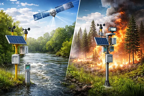
A real-time monitoring network for floods or fires typically consists of hundreds or thousands of distributed sensor nodes. These nodes measure environmental parameters such as temperature, humidity, soil moisture, river level, wind speed, atmospheric pressure and particulate concentration. In wildfire-prone regions, additional gas sensors detect carbon monoxide and volatile organic compounds, which often rise before flames are visible. For flood forecasting, ultrasonic or radar-based water level gauges are installed along rivers and drainage systems.
Communication is handled through low-power wide-area networks such as LoRaWAN and NB-IoT, which remain dominant in 2026 due to their energy efficiency and wide coverage. In remote mountainous or forested areas, satellite IoT connectivity is increasingly used, particularly through low-Earth orbit constellations that ensure data transmission even when terrestrial networks fail. This redundancy is critical during disasters, when traditional infrastructure may be damaged.
Edge computing has become a defining feature of modern deployments. Instead of sending all raw data to central servers, local gateways preprocess and filter information. This reduces latency and bandwidth use, enabling near-instant alerts when thresholds are exceeded. For example, if a sudden spike in river level coincides with heavy rainfall intensity measured by nearby sensors, the system can automatically escalate warning levels within seconds.
Data Integration and Predictive Modelling
Collecting data is only the first step. The real value of sensor networks lies in how that data is analysed. In 2026, machine learning models are routinely integrated into environmental monitoring systems. These models are trained on historical flood maps, rainfall patterns, vegetation dryness indices and previous fire spread trajectories. By combining real-time inputs with historical datasets, they generate short-term forecasts that are significantly more accurate than static threshold-based systems.
Hydrological models now assimilate live river basin data every few minutes, improving flash flood prediction windows from hours to, in some cases, 20–40 minutes of actionable lead time. While that may seem limited, for emergency management teams it can mean the difference between controlled evacuation and chaotic response. Similarly, wildfire spread simulations integrate wind direction, slope gradient and fuel load data in real time, recalculating probable fire fronts continuously.
Importantly, transparency and validation are central to trustworthy forecasting. Public agencies increasingly publish model performance metrics, false alarm rates and calibration methods. This openness strengthens institutional credibility and aligns with broader standards of accountability in environmental risk management.
Flood Prediction Systems in Practice
Real-world implementations demonstrate how theory translates into impact. In the United Kingdom, the Environment Agency has expanded its network of automated river level stations and rainfall gauges, integrating them with digital flood forecasting tools. Data is updated at intervals as short as 15 minutes in high-risk catchments. Local councils receive automated alerts, while public warning systems distribute messages via mobile networks and dedicated apps.
In the Netherlands, where flood defence is a national priority, sensor arrays are embedded directly into dikes and storm surge barriers. These sensors measure structural strain, seepage and groundwater pressure. By analysing anomalies in these indicators, engineers can detect weaknesses before visible damage occurs. This predictive maintenance approach reduces the likelihood of sudden failures during extreme weather events.
Urban environments are also adopting smart drainage monitoring. Cities such as Copenhagen and Hamburg deploy sensors within stormwater systems to monitor flow rates and blockage risks. When heavy rainfall is forecast, automated valves and retention basins can be managed dynamically, reducing overflow into streets and residential areas.
Wildfire Detection and Early Warning
Wildfire monitoring relies heavily on distributed temperature and smoke detection networks installed in forests and peri-urban zones. In Spain and Portugal, where summer heatwaves are intensifying, solar-powered sensor nodes transmit environmental readings continuously. When abnormal heat signatures combine with rapid drops in humidity and increased wind speeds, the system flags a high-risk scenario.
Thermal imaging cameras mounted on watchtowers and connected to AI-based image recognition systems complement ground sensors. These systems can distinguish between actual smoke plumes and false positives such as dust or mist. By 2026, detection times in some monitored regions have been reduced to under ten minutes from ignition, dramatically improving response capacity.
Integration with satellite data adds another layer of reliability. The European Copernicus programme provides near-real-time Earth observation imagery, which is cross-referenced with local sensor alerts. This multi-source verification reduces uncertainty and supports coordinated action between regional fire brigades and civil protection authorities.

Challenges, Reliability and Future Development
Despite technological advances, sensor networks face practical constraints. Hardware durability remains a concern in extreme conditions. Flood sensors must withstand debris impact and prolonged submersion, while wildfire sensors are exposed to intense heat and smoke. Regular maintenance schedules and remote diagnostics are therefore essential components of system design.
Data reliability is another critical factor. Sensor drift, calibration errors or communication outages can produce misleading signals. To mitigate this, modern systems apply redundancy: multiple sensors monitor the same parameter within a defined radius. If one node reports an anomaly inconsistent with neighbouring data, algorithms flag it for verification rather than triggering automatic escalation.
Cybersecurity has gained prominence as environmental monitoring becomes digitally interconnected. In 2026, regulatory frameworks in the EU require critical infrastructure operators to implement encryption, authentication protocols and intrusion detection mechanisms. Protecting sensor networks from tampering is not only a technical necessity but a matter of public safety.
The Road Ahead for Real-Time Environmental Monitoring
Looking forward, integration between climate modelling and local sensor grids is expected to deepen. Rather than functioning as isolated warning tools, sensor networks will increasingly feed into regional climate adaptation strategies. Urban planners already use aggregated sensor data to redesign drainage capacity and adjust land-use zoning in flood-prone districts.
Advances in energy harvesting, including improved photovoltaic materials and micro-wind turbines, are extending the operational life of remote sensors. This reduces maintenance costs and expands coverage into previously inaccessible areas. At the same time, miniaturisation allows denser deployments, improving spatial resolution and forecasting precision.
Ultimately, the strength of real-time sensor networks lies in their ability to transform environmental monitoring from reactive observation into proactive risk management. When combined with transparent governance, rigorous validation and community engagement, these systems provide a practical and measurable contribution to safeguarding lives, infrastructure and ecosystems in an era of escalating climate threats.